GPS validation markers

Find out how to use GPS validation markers and where to find them.

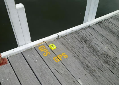
Global Positioning System (GPS) satellite navigation validation markers are unique visible markers located at a number of public boat ramps and jetties.

Mariners or owners of portable GPS units can use the markers to validate their position and map datum settings.

These marks are small, flat, yellow plastic markers similar to road lane markers or 'cat's eyes'. 

Yellow GPS marker on wooden jetty
 

How to use a GPS marker

  1. Manoeuvre your GPS unit as close to the yellow cat's eye marker as possible. These markers will be placed either on the bitumen road surface, allowing you to position your vessel directly over them prior to launching, or at the 'T' section of the service jetty for vessels already in the water.
  2. Ensure that your GPS unit is tracking at least five satellites and is set to the correct coordinate type (LAT/LONG or UTM) and datum (WGS84/GDA94).
  3. Make sure your GPS unit display coordinates match the surveyed coordinates of the marker. Agreement with the coordinates shown on the Department of Transport website should be possible to within 15 metres or 0.008 minutes.

  GPS validation markers map

Surveying and Spatial Science Institute (SSSI) member surveyors selected points at jetty and boat ramps from Esperance to Derby.

You can enter the values for each marker as a waypoint to assist with your safe return. These coordinates may be critical if people are fishing near designated Marine Protected Areas or using digital map charts.

Use the interactive map below to find coordinate information for each GPS marker.

The map may take a few seconds to load.

Opens in a new window Department of Primary Industries and Regional Development: Management of marine protected areas


Page last updated: Thu Apr 18 2024 4:01:49 PM