Navigation markers and buoys

Find out how to understand and use navigation aids in Western Australia.

Navigation marks, lights and buoys help you to safely navigate waterways and avoid hazards.

Take time to study a nautical chart and the buoyage (the system of buoys) to familiarise yourself with their meaning.

Western Australia uses an internationally recognised uniform coding system of navigation marks known as the IALA buoyage system A.

  Lateral marks

Those topped  by a red can shape are called Port Marks, and those  topped by a green triangle shape are called Starboard  Marks.
Those topped by a red can shape are called Port Marks, and those topped by a green triangle shape are called Starboard Marks.

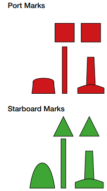
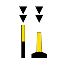
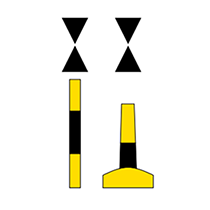
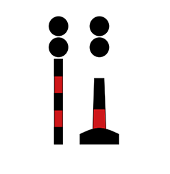
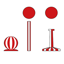
Lateral marks indicate the port and starboard sides of channels. The marks topped by a red can shape are called Port Marks, and those topped by a green triangle shape are called Starboard Marks.


Coming in, going out rule

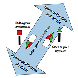
When entering harbours or travelling upstream in a river, make sure port hand marks are on your port side and starboard hand marks are on your starboard side.

When leaving harbours or travelling downstream, make sure port hand marks are on your starboard side and starboard hand marks are on your port side.

Coming in and going out rule

Tip: One way to remember this is the saying ‘there's some red, port, left in the bottle’ when travelling upstream.

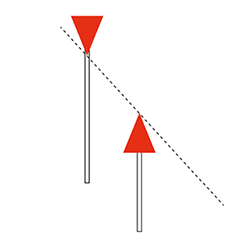
Lateral marks are not always placed in pairs where you simply pass between them. When you see just one, you will need to bear in mind the upstream-downstream principle.

  Cardinal marks

Cardinal marks are used where lateral marks would be inappropriate or confusing.

They indicate the safe side to pass a danger or a feature, such as a bend in channel or end of a shoal.

Cardinal marks indicate the compass direction of the safest water, so it is useful to have a compass on board your vessel.

You should pass to the:

  • east of an east cardinal mark
  • south of a south cardinal mark
  • west of a west cardinal mark
  • north of a north cardinal mark.

Cardinal mark colours and top marks

The top marks and arrangement of the cones show which type of cardinal mark it is – north, south, east or west. The cones on top point in the direction of the black segment of the pillar or buoy.

North cardinal mark
North cardinal mark

North cardinal mark

  • Both cones point up.
  • Black band at the top and yellow at the bottom.
East cardinal mark
East cardinal mark

East cardinal mark

  • One cone points up and the other points down.
  • Black bands at top and bottom with a yellow band in the middle.
South cardinal mark
South cardinal mark

South cardinal mark

  • Both cones point down.
  • Yellow band on top and black band on the bottom.
West cardinal mark
West cardinal mark

West cardinal mark

  • Cones point in towards each other.
  • Yellow bands on the top and bottom with a black band in the middle.

Lights on cardinal marks

Cardinal marks also have flashing white lights to help you see them at night or in poor light conditions.

The lights patterns almost follow the clock face:

  • 3 o'clock = East Cardinal: 3 flashes
  • 6 o'clock = South Cardinal : 6 flashes and 1 long
  • 9 o'clock = West Cardinal: 9 flashes
  • 12 o'clock = North Cardinal: continuous flashing.

The long extra flash for south, and the continuous flash for north are to avoid confusion if you lose track with your counting.

  Leads

Lead marks
Lead marks

Lead marks are a pair of triangular navigation marks used to guide vessels through a shallow or dangerous channel.

They are usually used to enter a harbour, anchorage or navigate a channel.

They are separated in distance and elevation, so that when the two triangles are lined up vertically they provide a bearing.

Steer your vessel to keep the rear lead mark directly above the front lead mark.

  Sectored lights

Sectored lights are navigation aids that help to guide vessels through shallow or dangerous waters.

Generally there are 3 lights of different colours, each identifying a sector of an arc:

  • White sector: Generally be a safe water area.
  • Red or green sectors: Areas to avoid.

Sectored lights may vary in colour or purpose. Check the relevant nautical chart for the light's meaning, purpose and to determine the extent of the safe passage.

Woodman Point sectored lights

Example of sectored lights on a nautical chart

The lights in this nautical chart demonstrate that the you are on the recommended course as long as you keep within the white sector of the light. If the light colour shifts to red or green, you need to adjust your course to return to the white sector of the light.

Isolated danger marks

Isolated danger marks

Isolated danger marks indicate a specific danger with navigable water all around.

The mark is a black pillar with a red band in the middle with 2 black sphere top marks.

If an isolated danger mark is lit, it will have a white light flashing in groups of 2.

In general, keep clear of an isolated danger mark.

Safe water marks

Safe water mark buoys

Safe water marks indicate that there is safe water all around.

It is often used to mark the seaward end of channels into ports.

They are sometimes used to mark the centre of a channel; or are used in a series down the middle of a channel instead of lateral marks on the edges of the channel.

Safe water marks have red and white vertical stripes and may have a red top mark.

If a safe water mark is lit, it will have a white light flashing in an occulting or isophase pattern, or 1 long flash every 10 seconds.

Special marks

Special mark buoy
Special mark buoy

Special marks are used to indicate special areas or features, such as:

  • traffic separation marks
  • spoil ground, such as for waste or dredging material
  • aquaculture.

Special marks are yellow and have a cross-shaped top mark.

If lit, a special mark will have a yellow light that flashes in a different pattern to cardinal, isolated danger and safe water marks.

  Resources

Markers, Buoys and Beacons guide

Markers, buoys and beacons sticker

A sticker is available providing information about markers, buoys and beacons.

For a copy of the markers, buoys and beacons quick reference sticker, email edboat@transport.wa.gov.au


International System of Buoys guide

To find out more about the IALA buoyage system, download the International System of Buoys guide below. 

  Reporting navigation hazards and faulty aids

You should report broken or faulty navigation aids and navigational hazards to either:

Navigational Safety: 13 11 56 (Monday to Friday am to pm) or navigational.safety@transport.wa.gov.au

Water Police Co-ordination Centre: (08) 9442 8600 (after hours)

When you report a faulty navigational aid, include the:

  • location
  • navigation aid identification number
  • type of fault, such as missing top marks or broken or malfunctioning lights.

When reporting a hazard, include the location and type of hazard.

Page last updated: Wed Jun 21 2023 10:46:34 AM