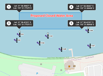
Fireworks display
In order to conduct a fireworks display on or over navigable waters, you will need to submit an application form to close waters.
Australia Day 2022 restrictions and closures
Overview for 2022
Boat owners taking to the water for the City of Perth Australia Day Skyworks on 26 January 2022, are advised to be aware of special restrictions for Perth Water on the day.
Department of Transport's Marine Officers controlling the on-water activities for the event recommend boat owners complete a thorough check of safety equipment on board their vessel and ensure navigation lights are working.
It is also recommended that lifejackets, distress flares and a suitable anchor be carried on board when on the river. For additional information such as where to go and how to get there visit the City of Perth Australia Day Skyworks website.
Speed limit
An 8 knot speed limit will be in place from the Narrows Bridge to Causeway Bridges including all of Perth Water from 3:00pm on the 26 January 2022 until sunrise on 27 January 2022. This excludes the existing 5 knot speed restricted area on the Perth side of Heirisson Island.
Closures
The centre section of Perth Water (as marked in yellow, please refer to the map) will be closed to all vessels from 3:00 pm until 9:45 pm including passenger pick up and drop off from Barrack Street and Mend Street jetties, pick up and drop off from Elizabeth Quay is allowed but a 10 minute time limit applies.
- The Belmont Ski area will be closed to Water Skiing from 3:00 pm on 26 January 2022 until 8:00 am 27 January 2022.
- There will be an exclusion zone (as marked in red, please refer to map) around the firework barges and pontoons within Perth Water from 6:00am on the 25 January 2022 until 8:00 am on the 27 January 2022.
- Out from the eastern end of Sir James Mitchell Park adjacent to Ellam Street, a 100 by 240 metre exclusion zone will be in place between 6:00 am on the 13 January 2022 until midnight on the 31 January 2022 to facilitate the safe loading and unloading of event pyrotechnics.
- Following the event, an announcement will be broadcast on marine band radios 27 Mhz channel 88 and VHF channels 9 and 16 to reopen Perth Water.
View the temporary notices to mariners for more information on area closures.
Anchoring
Anchoring is only permitted in the designated spectator areas. Skippers anchor at their own risk and are reminded to ensure that there is sufficient water depth for their vessel, also to be courteous to other boaters, don’t push in and ensure you have adequate swing room between other vessels when anchoring.
Swimming
Swimming is prohibited from 3:00 pm on 26 January 2022 until sunrise on 27 January 2022 in Perth Water between the Narrows Bridge and the Causeway Bridges.
Radio
While it is not a requirement for all vessels to be fitted with a radio, boats fitted with one are asked to:
- Monitor Channel 88 27 MHz or VHF Channel 16 and Channel 9.
- Use the call sign 'Marine Command' to contact Department's Marine Officers if required.
A message will be broad-cast on these frequencies advising vessels of the closing and reopening of Perth Water.
River closure guides
Download the river closures and restrictions map below.
Australia Day Skyworks: River closures and restrictions map (2022) | Kb | |
Australia Day Skyworks: Letter to commercial operators (2022) | Kb | |
Closed waters information
Where fireworks are to be held on or over navigable waters it is a requirement of the Department of Mines, Industry Regulation and Safety that the waters are closed by the Department of Transport (DoT) to boating and swimming. The closure is for safety measures during the set up and display of fireworks.
The application process allows for the closure to be assessed to ensure that all waterway users are taken into consideration, that there are a sufficient number of suitable support craft to maintain the required closure area as well as adequate fire fighting equipment for the duration of the display.
It is a legal requirement for DoT to publish notices to close waters. The cost of any publication is the responsibility of the applicant.
Application and approval process
The process for applying to close waters for a fireworks display includes;
- Application to Close Waters (Fireworks) - this form must be completed by licensed fireworks contractor's conducting fireworks displays on or over navigable waters.
- Six (6) week processing period - all applications must be submitted a minimum of 6 weeks prior to the fireworks display taking place.
- Waterway map / chart - all applications must be accompanied by a chart or map clearly showing the firing point(s) and requested exclusion zone. Please refer to the information on this page for more details.
- Safety Management System - the DoT requests that a 'safety management plan' and risk assessment is also supplied relating to the display. If the required exclusion zone is over known vessel storage locations such as mooring control areas or boat harbours the proponent must include how the risk to those vessels will be mitigated.
- Other Approvals - applicants are responsible for obtaining all other approvals required to conduct the fireworks display including but not limited to:
- Department of Mines, Industry Regulation and Safety.
- Port Authority.
- Marina Management.
- Local Government Authority.
Application for closed waters (fireworks)
If you would like to conduct a fireworks display on or over navigable waters, you will need to submit an application form to close waters to the Department of Transport, at least 6 weeks prior to the fireworks display.
Fireworks display: Application to close waters (form) | Kb | |
Waterway chart / map requirements
Coordinates of the firing point(s) must be provided in degrees and decimal minutes format (DDM), accurate to 3 decimal places.
e.g. Latitude 31° 57.842'S, Longitude. 115° 51.203'E as a center point of circular exclusion zones.
If the required exclusion zone is a non-circular shape, please include the coordinates at each point, or change of direction.
An example is provided below as a guide as to what is required when submitting a map of the firing point to DoT.
