

Pilbara
Mariners are advised that maintenance and dredging operations are scheduled to be conducted at Beadon Creek, Onslow from 15 September to 17 October 2026, daily.
Dredging operations will be conducted during daylight hours only. Activities outside daylight hours will be limited to the safe securing, maintenance, and preparation of equipment for continuation of dredging operations.
Operations will be undertaken from split hopper barges ‘AOM 1802’ and ‘AOM 23’, and work vessels "BHD Woomera", "P.T. Monto", "M.V Groote Eylandt", and "Bay Lass".
All vessels taking part in these works will display lights and shapes in accordance with the Prevention of Collisions in State Waters Regulations 1983 at all times.
Operators will monitor Marine VHF Channels 9 and 6.
Mariners are advised to maintain a proper lookout at all times and proceed with caution when navigating in this area.
Location Map
.png)
Location: 21° 38.6992'S 115° 7.8994'E
Start date: 15/9/2026
End date: 17/10/2026
Issued: 16/9/2026
Notice number: 7002
Mariners are advised that six (6) channel markers have been removed as preparation for the upcoming maintenance dredging works in Beadon Creek, Onslow.
Temporary orange markers with yellow flashing lights (Fl. 2s) are to be installed in place of the channel markers until works are completed.
Navigational Aid Locations:
• Starboard Buoy BN07: -21: 38.3002, 115: 7.9806
• Port Buoy BN08: -21: 38.319, 115: 8.0344
• Starboard Buoy BN09: -21: 38.5272, 115: 7.8866
• Port Buoy BN10: -21: 38.5502, 115: 7.9316
• Port Buoy BN12: -21: 38.4314, 115: 7.9825
• Special Marker Buoy Y01: -21: 38.6061, 115: 7.9177
Mariners are advised to maintain a proper lookout at all times and proceed with caution when navigating in this area.
Location: -21: 38.5245'S 115: 7.9097'E
Start date: 15/9/2026
Issued: 15/9/2026
Notice number: 7000
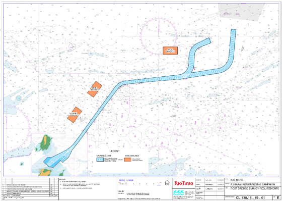
Mariners are advised that survey and maintenance dredging works will be conducted within the Port of Port Walcott. Survey works will commence on 13 of August 2026 with dredging works to commence around 25 August through to the end of September 2026. Operations will be conducted on a 24-hour basis.
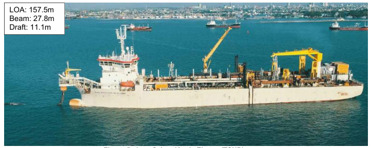
Operations will be undertaken by the survey vessels Pure Adrenaline and Black Jack, together with the 157.5m LOA Trailer Suction Hopper Dredge “Juan Sebastian de Elcano” and sweep vessel MTS Vantage.
All vessels taking part in these works will display lights and shapes in accordance with the Prevention of Collisions in State Waters Regulations 1983 at all times.
Mariners are advised to maintain a proper lookout at all times and proceed with caution when navigating in this area.
Chart for Dredging Area.
Vessel Juan Sebastian
Location: -20: 34.988'S 117: 10.993'E
Start date: 13/8/2026
End date: 30/9/2026
Issued: 13/8/2026
Notice number: 6965
Mariners are advised that LNGT4 light (LNG Turning Basin) has been reported as unlit.
Mariners are advised to maintain a proper lookout at all times and proceed with caution when navigating in this area.
Location: -20: 48.9392'S 115: 29.3006'E
Start date: 4/6/2026
Issued: 4/6/2026
Mariners are advised that nineteen (19) environmental monitoring buoys have been deployed in waters adjacent to the Passage Islands, Pilbara in the following locations:
Locations:
• 20° 51.069' S, 115° 48.718' E
• 20° 49.864' S, 115° 52.720' E
• 20° 58.139' S, 115° 58.939' E
• 20° 59.381' S, 115° 55.591' E
• 21° 01.403' S, 115° 59.689' E
• 21° 03.331' S, 115° 54.448' E
• 21° 03.125' S, 115° 56.102' E
• 21° 03.145' S, 115° 55.913' E
• 21° 02.740' S, 115° 56.423' E
• 21° 00.515' S, 115° 56.537' E
• 21° 01.693' S, 115° 56.498' E
• 21° 03.435' S, 115° 55.589' E
• 21° 02.864' S, 115° 55.794' E
• 20° 50.568' S, 115° 50.671' E
• 20° 50.342' S, 115° 50.321' E
• 20° 50.386' S, 115° 51.440' E
• 20° 50.890' S, 115° 49.999' E
• 20° 49.621' S, 115° 51.309' E
• 20° 51.454' S, 115° 49.942' E
The buoys are yellow in colour, approximately 1250 mm in diameter, and are fitted with lights exhibiting a Fl Y 4s (Flashing Yellow, 4 seconds) characteristic.
Mariners are advised to maintain a proper lookout at all times and to navigate with caution when operating in the vicinity of these buoys.
Location: -20: 59.3458'S 115: 51.4800'E
Start date: 23/4/2026
End date: 2/11/2026
Issued: 2/4/2026
Notice number: 6807
Port users are advised that I have today declared Beadon Creek Channel Declared Depth as 5.2 metres.
Refer also to the Temporary Notice to Mariners (TNTM) no. 6732 for information regarding a temporary restriction of depth to 4.7 metres and subsequent narrowing of the channel on the Eastern Side as delineated by two temporary Port Hand Buoys located at -21: 38.51616'S, 115: 7.93618'E & -21: 38.56555' S, 115: 7.91258' E
Authorised by: Captain P.A. Dwyer, Harbour Master, Port of Onslow, Maritime Division, Department of Transport and Major Infrastructure, WA
Location: -21: 38.51616'S 115: 7.93618'E
Start date: 12/2/2026
Issued: 12/2/2026
Notice number: 6742
Please be advised Beadon Creek Channel Depth has been promulgated to a least Depth of 5.2m from 10 February 2026.
Mariners are also advised that the Eastern side of the approach channel into Beadon Creek has an area where the depth is temporarily restricted to 4.7 metres.
The area is marked by two temporary Port Hand Buoys in position -21: 38.51616'S, 115: 7.93618'E & 21: 38.56555' S, 115: 7.91258' E, lit with a yellow light and flashing every two seconds.
Mariners are advised to navigate with caution.
Authorised by: Captain P.A. Dwyer, Harbour Master, Port of Onslow, Maritime Division, Department of Transport and Major Infrastructure, WA
Location: -21: 38.51616'S 115: 7.93618'E
Start date: 4/2/2026
Issued: 4/2/2026
Notice number: 6732
Mariners are advised that there is a large yacht sunk in the Hampton Harbour mooring area.
Mariners are advised to navigate the area with caution.
Location: -20: 39.938'S 116: 41.574'E
Start date: 12/11/2025
Issued: 12/11/2025
This Notice remains in force until superseded.
Port users are advised that I have today Declared Depths
• Onslow Salt Channel Minimum Declared Depth = 10.75 metres
• Onslow Salt Swing Basin Minimum Declared Depth = 10.70 metres
• Onslow Salt Berth Pocket Minimum Declared Depth 12.94 metres.
Authorised by: Captain P.A. Dwyer, Harbour Master, Port of Carnarvon, Maritime Division, Department of Transport and Major Infrastructure
Location: -20:40.4615'S 115:0.5372'E
Start date: 26/9/2025
Issued: 26/9/2025
Notice number: 6575
Vessel masters are reminded that all vessels wishing to transit or operate within the port limit which either:
Have a LOA of 35 meters or greater; or
Are engaged in towing operations where the total length of the tow (measured from the bow of the towing vessel to the stern of the towed vessel) is 35 metres or greater.
Are required to engage the services of a suitably licensed marine pilot or the vessel Master must be the holder of a current Port of Cape Preston Pilot Exemption Certificate.
The requirements regarding Pilotage exemption certificates can be found at Division 4 of the Shipping and Pilotage (Ports and Harbours) Regulations 1966.
WALW - Shipping and Pilotage (Ports and Harbours) Regulations 1966 - Home Page
Applications can be made to the Department of Transport and Major Infrastructure Harbour Master’s office at port.ops@transport.wa.gov.au
Authorised by: Captain P.A. Dwyer, Harbour Master, Port of Carnarvon, Maritime Division, Department of Transport and Major Infrastructure
Location: -20:42.290'S 116:10.210'E
Start date: 18/8/2025
Issued: 29/8/2025
Notice number: 6551
Vessel masters are reminded that all vessels wishing to transit or operate within the port limit which either:
Have a LOA of 35 meters or greater; or
Are engaged in towing operations where the total length of the tow (measured from the bow of the towing vessel to the stern of the towed vessel) is 35 metres or greater.
Are required to engage the services of a suitably licensed marine pilot or the vessel Master must be the holder of a current Port of Barrow Island Pilot Exemption Certificate.
The requirements regarding Pilotage exemption certificates can be found at Division 4 of the Shipping and Pilotage (Ports and Harbours) Regulations 1966.
WALW - Shipping and Pilotage (Ports and Harbours) Regulations 1966 - Home Page
Applications can be made to the Department of Transport and Major Infrastructure Harbour Master’s office at port.ops@transport.wa.gov.au
Authorised by: Captain P. A. Dwyer, Harbour Master, Port of Barrow Island, Maritime Division, Department of Transport and Major Infrastructure.
Location: 20:49.1070'S 115:29.6101'E
Start date: 18/8/2025
Issued: 29/8/2025
Notice number: 6550
Vessel masters are reminded that all vessels wishing to transit or operate within the port limit which either:
Have a LOA of 35 meters or greater; or
Are engaged in towing operations where the total length of the tow (measured from the bow of the towing vessel to the stern of the towed vessel) is 35 metres or greater.
Are required to engage the services of a suitably licensed marine pilot or the vessel Master must be the holder of a current Port Walcott Pilot Exemption Certificate.
The requirements regarding Pilotage exemption certificates can be found at Division 4 of the Shipping and Pilotage (Ports and Harbours) Regulations 1966.
WALW - Shipping and Pilotage (Ports and Harbours) Regulations 1966 - Home Page
Applications can be made to the Department of Transport and Major Infrastructure Harbour Master’s office at port.ops@transport.wa.gov.au
Authorised by: Captain P. A. Dwyer, Harbour Master, Port Walcott, Maritime Division, Department of Transport and Major Infrastructure.
Location: -20:35.0793'S 117:11.1491'E
Start date: 18/8/2025
Issued: 29/8/2025
Notice number: 6548
Vessel masters are reminded that all vessels wishing to transit or operate within the port limit which either:
Have a LOA of 35 meters or greater; or
Are engaged in towing operations where the total length of the tow (measured from the bow of the towing vessel to the stern of the towed vessel) is 35 metres or greater.
Are required to engage the services of a suitably licensed marine pilot or the vessel Master must be the holder of a current Port of Onslow Pilot Exemption Certificate.
The requirements regarding Pilotage exemption certificates can be found at Division 4 of the Shipping and Pilotage (Ports and Harbours) Regulations 1966.
WALW - Shipping and Pilotage (Ports and Harbours) Regulations 1966 - Home Page
Applications can be made to the Department of Transport and Major Infrastructure Harbour Master’s office at port.ops@transport.wa.gov.au
Authorised by: Captain P. A. Dwyer, Harbour Master, Port of Onslow, Maritime Division, Department of Transport and Major Infrastructure.
Location: -21:40.4615'S 115: 0.5372'E
Start date: 18/8/2025
Issued: 29/8/2025
Notice number: 6549
Mariners are advised that a 20m fishing vessel is currently grounded on the rocks at the North end of North West Island, in the Montebello islands.
Mariners are advised to proceed with caution in the area due to the presence of debris, including large coils of rope and floating fiberglass.
Location: -20: 21.5222'S 115: 31.3589'E
Start date: 14/5/2025
Issued: 14/5/2025
Notice number: 6455
Mariners are advised a 12.5 metre catamaran has run aground at Cape Legendre, Dampier Archipelago.
Mariners are advised to proceed with extreme caution when navigating the area and be aware for potential debris.
Location: -20: 21.5300'S 116: 49.8000'E
Start date: 22/4/2025
Issued: 22/4/2025
Notice number: 6429
Mariners should exercise caution when launching and retrieving their vessels at the Spoilbank Marina boat ramp in Port Hedland, as algae buildup, particularly at low tide, can make the ramp slippery.
The ramp is regularly cleaned however mariners should still be cautious when using the facility.
Location: -20:18.3340'S 118:35.3154'E
Start date: 7/3/2025
Issued: 7/3/2025
Notice number: 6372
Mariners are advised that one (1) commercial mooring is scheduled to be installed on 12 October 2023 and 13 October 2023 in the Enderby Island vicinity:
The above commercial mooring is yellow in colour, unlit and approximately 1.8m in diameter.
Only licensed and authorised vessels may use the above commercial mooring buoy at any time.
Mariners are advised to navigate with caution when transiting the area and keep well clear of the above commercial mooring buoy.
Location: -20: 36.785'S 116: 33.818'E
Start date: 3/10/2023
Issued: 3/10/2023
Notice number: 5832